Worksheets and No Prep Teaching Resources
Reading Comprehension Worksheets
Geography
Cruising the South Atlantic Region

Geography
Geography


Cruising the South Atlantic Region
Print Cruising the South Atlantic Region Reading Comprehension with Fourth Grade Work

Print Cruising the South Atlantic Region Reading Comprehension with Fifth Grade Work

Print Cruising the South Atlantic Region Reading Comprehension with Sixth Grade Work

Print Cruising the South Atlantic Region Reading Comprehension

Reading Level
     edHelper's suggested reading level:   grades 4 to 6
     Flesch-Kincaid grade level:   6.39

Vocabulary
     challenging words:    nonrenewable, subregions, subtropical, unpredictable, washington, humidity, silt, temperate, rugged, mines, spongy, steamy, inland, original, further, entire
     content words:    South Atlantic Region, South Region, North Carolina, South Carolina, West Virginia, United States Census Bureau, Atlantic Region, Northeast Region, South Atlantic, Atlantic Ocean


Cruising the South Atlantic Region
By Trista L. Pollard
  

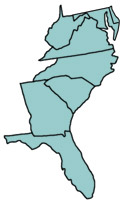
1     Leave the Northeast on Route 95 and you will enter the South Atlantic Region. This area is one of three subregions of the South Region. It has eight states and one district. The South Atlantic's geography can be enjoyed by car, boat, and train.
 
2     Six of the region's states were part of the thirteen original colonies. They are Delaware, Maryland, Virginia, North Carolina, South Carolina, and Georgia. West Virginia and Florida are the last two states. Washington, D.C., is a district. D.C. stands for District of Columbia. A district is an area that is used as government land. Washington, D.C., is the capital of our country. It is located between Maryland and Virginia. The United States Census Bureau lists Delaware and Maryland in the South Atlantic Region. However, some geographers include both states in the Northeast Region.
 
3     West Virginia is the only state in the South Atlantic that does not border the Atlantic Ocean. Florida also borders the Gulf of Mexico to its west. Most of Delaware and part of Maryland lie on the Delmarva Peninsula. Delmarva is named after Delaware, Maryland, and Virginia. A small part of Virginia is located on the peninsula. The state of Florida is also a peninsula.
 
4     The Delmarva Peninsula is part of the Atlantic Coastal Plain. Remember, this plain begins in New England. It covers most of the entire east coast to Florida. The coastal plain has low, flat land. Most of the land is sand and silt. There are also wetlands in the Outer Coastal Plain. Wetlands are areas of land that are covered by water. The coasts of Delaware, Virginia, and North Carolina have wetlands. The Inner Coastal Plain is further inland from the coast.

Paragraphs 5 to 15:
For the complete story with questions: click here for printable


Weekly Reading Books

          Create Weekly Reading Books

Prepare for an entire week at once!


Feedback on Cruising the South Atlantic Region
Leave your feedback on Cruising the South Atlantic Region   (use this link if you found an error in the story)


Geography
             Geography


Copyright © 2018 edHelper