Worksheets and No Prep Teaching Resources
Reading Comprehension Worksheets
Geography
Projecting the World

Geography
Geography


Projecting the World
Print Projecting the World Reading Comprehension with Sixth Grade Work

Print Projecting the World Reading Comprehension


Reading Level
     edHelper's suggested reading level:   grades 6 to 8
     Flesch-Kincaid grade level:   7.67

Vocabulary
     challenging words:    directions-north, distortion, Gerdhaus, pie-shaped, rhumb, west-with, mapmakers, cartographers, projector, relation, geographical, projection, relatively, grid, cylindrical, region
     content words:    Gerdhaus Mercator, On Conic, Winkel Tripel, National Geographic Society


Projecting the World
By Trista L. Pollard
  

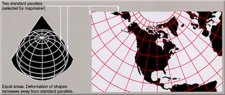
1     Years after agreeing that the Earth is a sphere, cartographers and scientists continue to map its surface. Early mapmakers relied on information from sailors and explorers. Today, they use computers, satellites, and cameras to get information about Earth. One tough task still remains. How do you make an accurate flat map out of a sphere? Gerdhaus Mercator had the right idea. He introduced one of the first map projections.
 
2     Map projections are pictures of the Earth that are drawn on flat maps. The Earth is a three-dimensional object. Cartographers use projections to draw this sphere on a two-dimensional surface, which is the paper. If you could place a projector light inside a globe, the image you would get would be a projection. This image would be projected onto a flat screen. Move the projector and the image changes. Mercator was the first geographer to use a projection. He designed his map in 1569. This is when the Mercator projection was made. Mercator designed the spaces between the meridians and parallels so that they could be drawn as straight lines. These lines were called rhumb lines. This was amazing since Earth was curved. Mercator also did not use a light projector! Sailors could use a compass that was set to a specific straight line. This straight line was connected to their home and to their destination. The sailors also had to adjust their compasses so that they could find the true magnetic north.
 
3     Just like Mercator's projection, map projections are based on our geographical grid. Geographers have to change this grid that is on a globe so that it can be accurate on a flat map. As they change this grid, they pay attention to four different concerns: area, direction, distance, and shape. When cartographers draw maps, they have to pay attention to the size of land features and water regions. Area focuses on the measurements of these features in relation to each other. Cartographers compare cardinal directions-north, south, east, and west-with their true locations on our geographic grid. Scale is another way to make sure that the distance between map locations is in relation to the true distances on Earth. Finally, they are also concerned about the shape of land and water. Cartographers want to make sure that the shapes of these features are close to their shapes on Earth.

Paragraphs 4 to 8:
For the complete story with questions: click here for printable


Weekly Reading Books

          Create Weekly Reading Books

Prepare for an entire week at once!


Feedback on Projecting the World
Leave your feedback on Projecting the World   (use this link if you found an error in the story)


Geography
             Geography


Copyright © 2018 edHelper