
Worksheets and No Prep Teaching Resources
Reading Comprehension Worksheets
Earth Science

Earth Science
|
Worksheets and No Prep Teaching Resources Reading Comprehension Worksheets Earth Science |
Earth Science |
| edHelper's suggested reading level: | high interest, readability grades 9 to 10 | |
| Flesch-Kincaid grade level: | 7.14 |
|
The Best View of Earth?
By Trista L. Pollard |
|
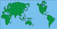 1 A journey into the world of maps introduces you to globes, map symbols, legends, and directions. You are even told there are different types of maps for different purposes. However, did you know that globes are the most accurate model of our planet? That's right; if you want the best view of Earth, globes are the way to go. Before you run out and fill your bedroom with globes, there is something you should know. In addition to being hard to carry in your pocket, globes do not show much of the surface detail. The tool that is best for that job is a flat map.
 |
Create Weekly Reading Books
Prepare for an entire week at once! |
| Leave your feedback on The Best View of Earth? (use this link if you found an error in the story) |
|
Earth Science
|
 |
High School Reading Comprehensions and High School Reading Lessons
|
 |
Special Education Science Materials for Teachers
|