edHelper.com
Earth Science
Other Types of Maps


Other Types of Maps
Reading Level
     edHelper's suggested reading level:   grades 9 to 10
     Flesch-Kincaid grade level:   8.12

Vocabulary
     challenging words:    isograms, availability, hydrologists, kiosk, presenting, identical, confusion, meteorologists, planet, addition, extremely, occur, previous, determine, climate, valuable
     content words:    Old Navy


Print Other Types of Maps
     Print Other Types of Maps  (font options, pick words for additional puzzles, and more)


Quickly Print
     Quickly print reading comprehension


Proofreading Activity
     Print a proofreading activity


Feedback on Other Types of Maps
     Leave your feedback on Other Types of Maps  (use this link if you found an error in the story)


Other Types of Maps
By Trista L. Pollard
  

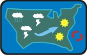
1     A map a day keeps confusion away!
 
2     If you look around, you can find a map for any topic. Every mall has a map kiosk that let's you see how far you are from Old Navy. There are maps of city bus routes and subway lines. There are even maps in candy boxes so that you can avoid the piece of candy you hate. Without maps, our world would be lost.
 
3     Earth scientists around the world will tell you that maps are extremely important. Hydrologists use maps to show water locations and flow patterns. Scientists need to monitor the flow of water on the Earth's surface and underground. Mapping the location and flow of water helps scientists to predict water shortages. It also helps scientists to find suitable areas to build power plants and new communities. Earth scientists use maps to show the flow of air across the planet's surface. To produce these maps, scientists collect and plot their data to form isograms. These lines of identical information help scientists to study the different systems on our planet.

Paragraphs 4 to 6:
For the complete story with questions: click here for printable


Copyright © 2009 edHelper