edHelper.com
Water


Driving Along the Ocean Floor, Part 1


Driving Along the Ocean Floor, Part 1
Reading Level
     edHelper's suggested reading level:   high interest, readability grades 5 to 7
     Flesch-Kincaid grade level:   6.21

Vocabulary
     challenging words:    fast-moving, downward, mudslides, margin, canyons, continental, flatter, mass, southeastern, submarine, during, lower, crust, along, solid, level
     content words:    Ice Age, Great Britain, North America, Grand Canyon


Print Driving Along the Ocean Floor, Part 1
edHelper.com subscriber options:
     Print Driving Along the Ocean Floor, Part 1  (font options, pick words for additional puzzles, and more)

     Quickly print reading comprehension

     Print a proofreading activity


Feedback on Driving Along the Ocean Floor, Part 1
     Leave your feedback on Driving Along the Ocean Floor, Part 1  (use this link if you found an error in the story)


Driving Along the Ocean Floor, Part 1
By Patti Hutchison
  

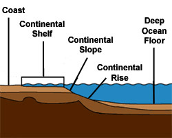
1     If you could drive your car along the ocean floor, you would see some interesting formations. The ocean floor has canyons, mountains, and plains just like the continents. But these formations are higher, wider, and flatter than those on land. The ocean also has more volcanoes than the continents. Let's examine some of these features.
 
2     You may think that a continent ends at the shoreline. This is not true! A continent extends into the ocean. The area where the continent meets the ocean floor is called the continental margin. This is a part of the continent that is under water. There are three parts to a continental margin.
 
3     This first part of the continental margin is called the continental shelf. This is a flat area that is covered with shallow water. The average depth of the water here is about 130 meters. The continental shelf slopes gently downward from the shoreline.
 
4     The width of the continental shelf is different around the world. Off the coast of southeastern Florida, there is almost no continental shelf. Off the shore of Siberia, it extends almost 1200 kilometers into the ocean.
 
5     Some scientists believe that the continental shelves were exposed during the last Ice Age. During this time, sea level was much lower than it is today. Great Britain was attached to Europe. Asia was linked with North America by the Bering land bridge. And there was a large, solid mass of land which is now the islands of the Bahamas. As the glaciers began to melt, sea level rose and covered these continental shelves.

Paragraphs 6 to 13:
For the complete story with questions: click here for printable


Copyright © 2008 edHelper