
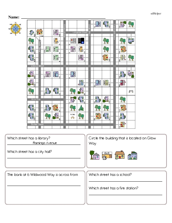
The worksheet titled starts by displaying a coordinate plane with a neighborhood situated on top. The neighborhood includes streets with names, houses and businesses with numbered addresses, and other features, like trees and picnic spots, in each square. Students use the coordinate grid to answer a series of questions that can include finding street names, buildings at certain addresses, or measuring the distance between two locations using a map scale.
There are two or four questions on each page, located in their own boxes. Lower grade levels feature simpler questions like, "Which street has a fire station?" while upper grade level worksheets feature multi-step word problems. One example gives students step-by-step directions, and they have to figure out where the directions lead on the map.
Having students answer questions about coordinate planes encourages the development of spatial and analytical thinking skills. You can also use coordinate planes to help students practice real-world navigation skills.
For example, you can draw a neighborhood on a coordinate plane and ask students a series of questions about what buildings are located where. You can also have students practice following directions by guiding them through a series of instructions to see where they end up on the map.
Plotting points on a coordinate plane can also be a fun way to have students practice ordered pairs and following directions. Graphing a series of dots can reveal a picture, like a shark or a butterfly.
Students can even create their own coordinate plane activities when they get the hang of it. Artistically inclined children may like mapping out a zoo on a coordinate plane or listing the ordered pairs to create a picture before asking a classmate to answer their questions.
Coordinate Plane Neighborhood
Coordinate Plane Neighborhood
GRADES:


Additional Educational Resources:
The Coordinate Plane Large Workbook - (Grade 6)
Ordinal Numbers and Position Large Workbook - (Grade 1)
Quick Assessment - Beginning Algebra: Exploring Algebraic Expressions - Variables, Expressions, and Equations