
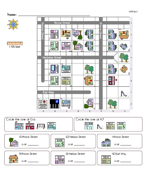
"Coordinate Plane Town: Measuring Distance on a Map, Finding Ordered Pairs, and More" is an engaging worksheet that gives students practice using a coordinate plane. Each page features a town with different houses, businesses, parks, and more in different squares. Then, students answer 16 complex questions about the little community shown in the grid. Questions include asking students to find which image is located at a given coordinate pair, some questions ask students to write the coordinate pair for a specific building, and other questions ask students to use the measurement key on the worksheet to determine the distance between two images.
Each coordinate grid has an x-axis that's labeled with letters and a y-axis that's labeled with numbers. Each question is located in its own box, so students have room to write their answer and show their thinking.
Answering questions about coordinate planes helps students build spatial and analytical thinking skills. It can help build connections between algebra and geometry, and it supports real-life navigation, gaming, and engineering skills.
When creating coordinate plane activities, choose graphs that are an appropriate size for the grade level you teach. Very small graphs can feature just a few boxes for young students, and larger planes can be used with older students. Avoid using all four quadrants as students learn and instead focus on the first quadrant as they build their graph skills.
Students can label dots on a coordinate plane, but it can be more fun for them to identify and draw shapes on a grid. You can tie their graph reading skills to real-life applications by drawing a neighborhood complete with houses, businesses, parks, and more in the squares of a coordinate plane. Then, you can ask students a series of questions about which pictures are located in which squares.
Using a coordinate plane is also a great way for students to practice measurement skills. Very young students can count the number of boxes between two items on a grid, while older students can use a map scale to measure the distance between two objects.
Coordinate Plane Town: Measuring Distance on a Map, Finding Ordered Pairs, and More
Coordinate Plane Town: Measuring Distance on a Map, Finding Ordered Pairs, and More
GRADES:
Additional Educational Resources:
Number Lines and Negative Numbers Large Workbook - (Grade 6)
Algebra Large Workbook - (Grade 5)
Quick Assessment - Exploring Positive and Negative Values: Comparing, Ordering, and Evaluating Integers