Sixth Grade
Worksheets
Mapping the Earth's Surface
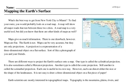
What's the best way to get from New York City to Miami? To find your route, you would probably look on a road map. A map will show all major roads that run between these two cities. A road map is a very useful tool, but did you know that there are other kinds of maps as well?
Maps give us much information. There is one drawback, however. Maps are flat. The Earth is not. Maps can be very accurate, but they are only projections. A projection is a representation of a three-dimensional object on a flat surface. Sort of like a photograph of you and your friends.
There are different ways to project the Earth's surface onto a map. One type is called the cylindrical projection. It is also sometimes called a Mercator projection. Another type is called the conic projection. Still another is called the azimuthal projection. Each one is useful in its own way. However, each can distort either the size or the shape of the landmasses. It is not easy to draw a three-dimensional object on a flat piece of paper!