Fourth Grade
Worksheets
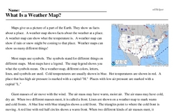
What Is a Weather Map?
Maps give us a picture of a part of the Earth. They show us facts about a place. A weather map shows facts about the weather at a place. A weather map can show what the temperature is. A weather map can show if rain or snow might be coming to that place. Weather maps can show us many different things!
Most maps use symbols. The symbols stand for different things on different maps. Most maps have a legend. The map legend shows you what the symbols mean. On a weather map, different colors, letters, lines, and symbols are used. Cold temperatures are usually shown in blue. Hot temperatures are shown in red. A place that has high air pressure is marked with a capital "H." Places with low air pressure are marked with a capital "L."
Giant masses of air move with the wind. The air mass may have warm, moist air. The air mass may have cold, dry air. When two different masses meet, it is called a front. Lines are shown on a weather map to mark warm and cold fronts. A blue line with blue triangles shows a cold front. The triangles point to where the cold front is moving. A red line with red half circles shows a warm front. When two different kinds of air masses meet, it causes a change in the weather. These lines show where major weather changes will be.